O Quy Ho Pass Sapa is a highlight of any trip to northern Vietnam, especially for travelers who love mountain views, cloud hunting, scenic drives, and highland landscapes. Sitting at over 2,000 meters above sea level, the pass connects Sapa with Lai Chau and offers some of the most dramatic scenery in the Hoang Lien Son range. This guide from Your Vietnam Travel will help you plan your visit with practical information on location, transport, best time, things to do and safety tips.
O Quy Ho Pass is located on National Highway 4D, connecting Sapa in Lao Cai Province with Tam Duong District in Lai Chau Province. The summit of the pass sits on the natural boundary between the two provinces, around 15–17 kilometers from Sapa town center.
The pass runs through the Hoang Lien Son mountain range, one of the most impressive mountain systems in northern Vietnam. This area is closely associated with Fansipan, the highest mountain in Vietnam and Indochina, standing at 3,143 meters above sea level.
From Sapa town, the common route follows Dien Bien Phu Street toward Silver Waterfall, passes the entrance area of Hoang Lien National Park and Tram Ton Ranger Station, then continues uphill to the pass summit. The road is paved but steep, winding, and often affected by fog, rain, or sudden weather changes.
O Quy Ho Pass is sometimes called Tram Ton Pass because the pass summit is near the Tram Ton area. It is also known as Hoang Lien Son Pass due to its location across the mountain range, and Cloud Pass because clouds often cover the upper section of the road.
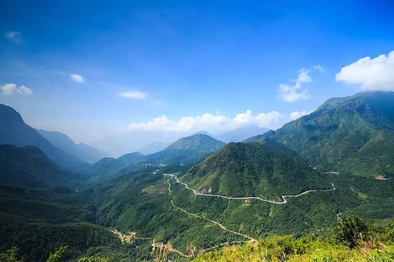
O Quy Ho Pass connects Sapa with Lai Chau (Source: Collected)
O Quy Ho Pass is famous because it combines dramatic mountain scenery, challenging roads, high-altitude weather, and some of the best viewpoints in Sapa. It is often listed among the “Four Great Mountain Passes” of northern Vietnam, together with Ma Pi Leng Pass in Ha Giang, Khau Pha Pass in Yen Bai, and Pha Din Pass between Son La and Dien Bien.
The pass is also considered one of the longest and most impressive mountain passes in Vietnam’s Northwest region. Stretching nearly 50 kilometers along National Highway 4D, it connects the cool misty side of Sapa with the warmer valleys of Lai Chau. This creates a striking contrast in climate and scenery between the two sides of the pass.
At over 2,000 meters above sea level, O Quy Ho offers wide views of deep valleys, sharp cliffs, rolling mountains, and clouds drifting across the Hoang Lien Son range. On clear days, travelers can see the slopes around Fansipan, the white stream of Silver Waterfall, and the layered mountains stretching toward Lai Chau.
The pass is especially popular for:
For many travelers, O Quy Ho Pass is not just a road between two provinces. It is one of the most memorable scenic journeys in Sapa.
The name “O Quy Ho” is often linked to local geography and folklore. One explanation says that the name comes from O Quy Ho village, located near the route along National Highway 4D. In local interpretation, the name is associated with the curved shape of the pass as it winds through the mountains.
A more romantic version comes from a local legend about an unfinished love story. According to the tale, a fairy fell in love with a young man named O Quy Ho. They met in the mountains, but their love could not last. Heartbroken, the fairy turned into a bird and flew around the mountain pass, calling the name of her lover. Since then, the pass has been known as O Quy Ho.
The pass also has several other names. “Hoang Lien Son Pass” refers to the mountain range it crosses. “Tram Ton Pass” is used because the summit area is near Tram Ton. “Cloud Pass” describes the mist and clouds that frequently cover the road, especially in the early morning, late afternoon, and cold season.
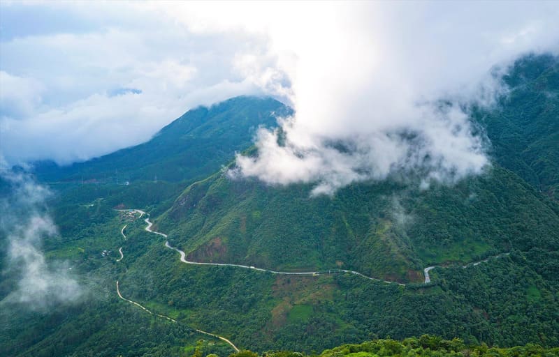
Cloudy scenery around O Quy Ho Pass in Sapa (Source: Collected)
O Quy Ho Pass offers different scenery throughout the year, from golden rice fields and cloud seas to spring flowers and winter frost.
Best time of day:
For a more detailed overview of weather, rice terrace seasons, and travel conditions, check out our guide to the best time to visit Sapa.
The easiest way to reach O Quy Ho Pass is from Sapa town. Most travelers visit the pass as a half-day trip or combine it with Silver Waterfall, Love Waterfall, Heaven Gate, and Rong May Glass Bridge.
From central Sapa, follow Dien Bien Phu Street toward National Highway 4D. Continue in the direction of Silver Waterfall, Hoang Lien National Park, and Tram Ton Ranger Station. From there, the road climbs toward O Quy Ho summit and continues into Lai Chau Province.
The distance from Sapa town to the summit area is around 15 - 17 kilometers. Travel time is usually 30 - 45 minutes by motorbike or car, depending on weather, road conditions, and stops along the way.
Common route:
Sapa town center → Dien Bien Phu Street → Silver Waterfall → Hoang Lien National Park entrance area → Tram Ton Ranger Station → O Quy Ho summit / Heaven Gate → Lai Chau side
A motorbike is the most flexible way to explore O Quy Ho Pass. It allows you to stop at viewpoints, cafes, waterfalls, and photo spots along the road. This option is best for experienced riders who are comfortable with mountain roads, sharp bends, steep slopes, and changing weather.
Before renting a motorbike, check the brakes, tires, lights, horn, mirrors, and fuel level. A semi-automatic or manual motorbike is usually better for mountain roads than a weak scooter, especially when going uphill or downhill. Always use a helmet and avoid riding fast.
If you are not confident riding on mountain passes, do not choose this option. The scenery is beautiful, but the road requires control, patience, and experience.
Going by car is safer and more comfortable, especially for families, groups, older travelers, or visitors traveling in winter or rainy weather. A taxi or private car from Sapa town can take you to the main viewpoints and nearby attractions.
This option is also better if you want to combine several stops in one day without worrying about driving, parking, or weather changes. For the best experience, choose a local driver familiar with the Sapa - Lai Chau mountain road.
If you start from Lao Cai City, travel first to Sapa town, then continue to O Quy Ho Pass. The distance from Lao Cai City to Sapa is around 35 - 40 kilometers and usually takes about one hour or more by car, depending on traffic and weather. From Sapa, follow the same route toward Silver Waterfall and Tram Ton.
Motorbiking from Lao Cai City to Sapa and then to O Quy Ho is possible, but it is not ideal for inexperienced riders because the route includes long uphill sections and mountain curves.
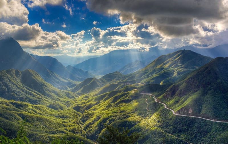
The drive itself is the main experience at O Quy Ho Pass. The road curves around steep mountain slopes, with cliffs on one side and deep valleys on the other. In many sections, clouds move across the road, revealing and hiding the mountains within minutes.
On clear days, the route offers wide views of the Hoang Lien Son range, terraced valleys, waterfalls, and distant villages. The scenery changes quickly as you move from the Lao Cai side toward the Lai Chau side. The Sapa side is usually cooler and mistier, while the Lai Chau side can feel warmer and sunnier.
For photographers and road trip lovers, the most beautiful sections are often around Silver Waterfall, Tram Ton, the pass summit, and the viewpoints facing Lai Chau.
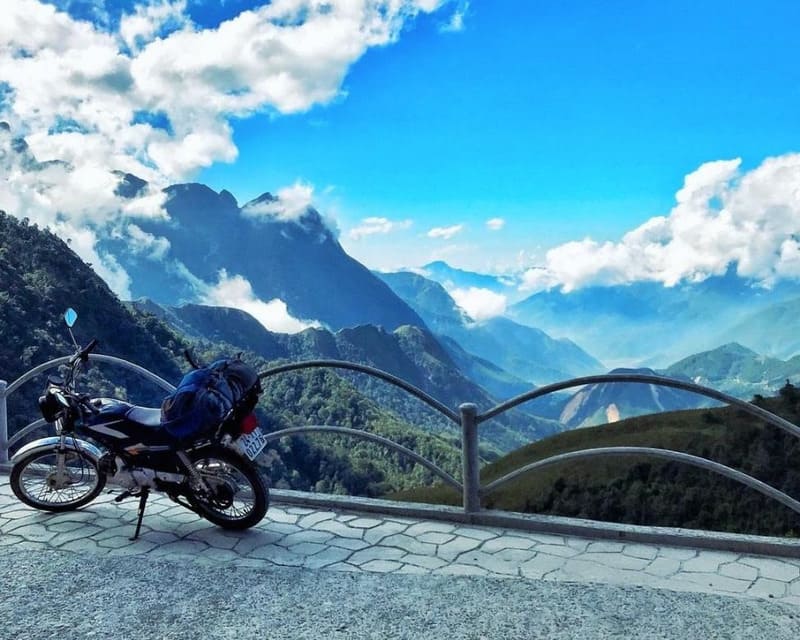
Mountain views unfold along the route through O Quy Ho Pass (Source: Collected)
O Quy Ho summit is one of the best cloud-hunting spots near Sapa. At over 2,000 meters above sea level, the summit often sits above or within layers of clouds. On the right day, travelers can see a sea of white clouds covering the valleys below, while mountain peaks rise above them.
The best months for cloud hunting are usually from October to March, especially after cold nights or when the weather shifts between mist and sunshine. Early morning and late afternoon are often the most atmospheric times, but visibility can change quickly.
Cloud hunting is never guaranteed. Weather in the Hoang Lien Son range is unpredictable, so it is best to check the forecast and stay flexible with your schedule.
Sunset is one of the most memorable moments at O Quy Ho Pass. When the weather is clear, the late-afternoon light spreads across the mountain slopes, turning the sky orange, pink, and purple. The view is especially beautiful from the summit area, roadside cafes, and viewpoints facing the Lai Chau side.
If you plan to watch sunset, arrive before 5:00 PM to find a safe viewpoint and enjoy the scene without rushing. After sunset, leave the summit before it gets fully dark. Fog and cold air often become stronger in the evening, making the road harder to drive.
O Quy Ho Heaven Gate, also called Sapa Heaven Gate or Tram Ton Heaven Gate, is one of the most famous viewpoints on the pass. From this area, visitors can admire the Hoang Lien Son mountains, floating clouds, and the road winding through the slopes.
This is a popular place for photos because it offers a high, open view of the surrounding landscape. Depending on the weather, you may see clear mountain layers, drifting mist, or a full cloud-covered valley. The view changes by season and even by hour.
Some tourist areas and photo spots around Heaven Gate may charge entrance fees. Check the price at the entrance before visiting, especially if you plan to use decorated photo zones, cafes, or private viewpoints.
Heaven Gate offers wide views over the mountains (Source: Collected)
Rong May Glass Bridge is one of the most adventurous attractions near O Quy Ho Pass. Located on the Lai Chau side of the pass, the site features a glass bridge and skywalk built high above the valley, offering a dramatic view of the mountains and cliffs.
Visitors can walk on transparent glass panels, look down into the valley, and take photos with the Hoang Lien Son range in the background. The site also has adventure-style activities such as skywalk experiences, depending on current operations.
Rong May Glass Bridge is best for travelers who enjoy heights, thrill experiences, and panoramic views. It is not necessary for every visitor, but it can be a good addition if you have enough time and want something more adventurous than a simple viewpoint stop.
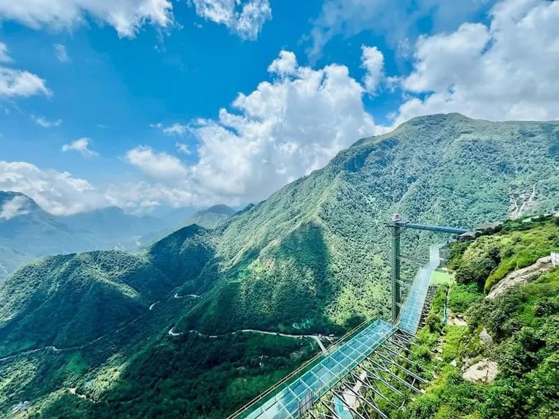
Rong May Glass Bridge above the mountain valley (Source: Collected)
The Lonely Tree is a well-known photo spot near O Quy Ho Pass. The image of a single tree standing against the mountain background has made it popular among young travelers and photographers. Nearby roadside cafes also offer simple drinks, grilled snacks, and viewpoints over the pass.
Stopping at a cafe is a good way to rest after the drive, especially in cold or foggy weather. A hot tea, coffee, grilled corn, or sweet potato tastes better in the mountain air. These stops also give you time to enjoy the scenery slowly instead of only taking photos and leaving.
When stopping along the road, choose safe parking areas. Do not stop in the middle of a bend, near blind corners, or on narrow sections of the pass.
O Quy Ho Pass is a strong photography location because it offers different subjects in one route: winding roads, mountain curves, clouds, waterfalls, forests, valleys, flowers, and local roadside life.
In spring, flowers such as peach blossoms, plum blossoms, and rhododendrons add color to the mountain scenery. In autumn, the wider Sapa region turns golden with rice terraces, especially if you combine O Quy Ho with Muong Hoa Valley or nearby villages. In winter, fog, frost, and occasional snow create a colder and more dramatic atmosphere.
For the best photos, use safe viewpoints instead of standing on the road. Weather changes quickly, so be patient. A foggy view may open up after a few minutes, revealing the mountains behind the clouds.
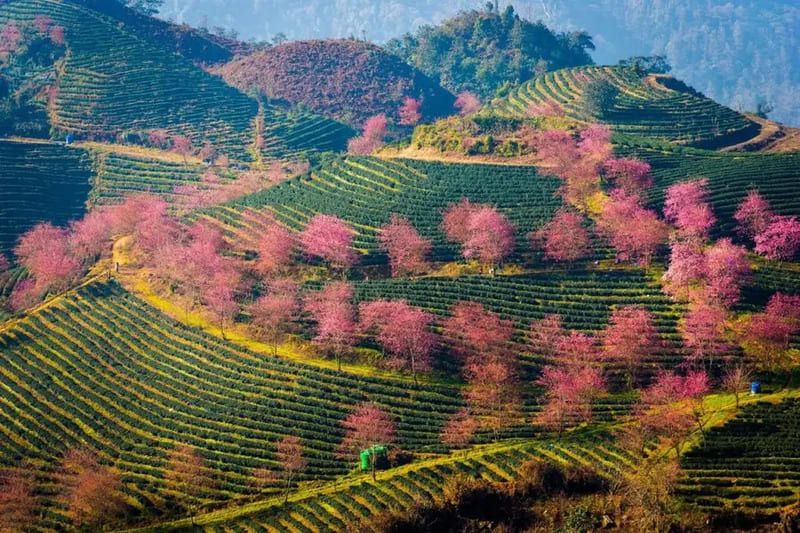
Tea hills and highland scenery near O Quy Ho Pass (Source: Collected)
O Quy Ho Pass is easy to combine with several famous attractions around Sapa, especially along the route from Sapa town to the pass summit.
Food around O Quy Ho Pass is simple, warm, and well suited to Sapa’s cool mountain climate. Around Silver Waterfall, Heaven Gate, roadside stalls, and Sapa town, travelers can find grilled snacks, local specialties, hotpot, and highland dishes.
If you try it, choose a clean and reputable local restaurant, especially if you are not used to strong-flavored dishes.
A little preparation can help you enjoy O Quy Ho Pass safely and make the most of its spectacular mountain scenery.
O Quy Ho Pass has steep slopes, sharp bends, and frequent fog, so it can be challenging for inexperienced riders. The road is paved, but wet or misty conditions may reduce visibility and make it slippery. Beginners should consider traveling by car, taxi, or with an experienced local driver.
The summit of O Quy Ho Pass is about 15 - 17 kilometers from Sapa town and usually takes 30–45 minutes to reach by car or motorbike. Most travelers combine the pass with nearby attractions such as Silver Waterfall, Love Waterfall, and Heaven Gate.
October and November are generally the best months thanks to dry weather, clear views, and excellent cloud-hunting conditions. December to February offers cold-weather scenery, while March and April are ideal for flowers and spring landscapes.
Yes. Many visitors reach O Quy Ho Pass by taxi, private car, or guided tour from Sapa. This option is more comfortable and suitable for families, groups, or travelers who prefer not to ride on mountain roads.
Snow occasionally appears during strong cold spells between December and February, although it is not guaranteed every year. More commonly, visitors may encounter frost, fog, and very low temperatures around the summit.
The drive from Sapa town to the summit takes around 30 - 45 minutes. To fully enjoy the viewpoints, cafes, waterfalls, and nearby attractions, allow at least half a day for the trip.
Yes. There are several roadside cafes, food stalls, and local eateries near the summit, Heaven Gate, and Silver Waterfall. Visitors can enjoy coffee, grilled snacks, and local specialties, while Sapa town offers a wider selection of restaurants and dining options.
O Quy Ho Pass combines everything that makes Sapa special: mountains, clouds, waterfalls, winding roads, and cool highland air. It is easy to reach from Sapa town, but the weather and road conditions require good planning. Visit during the right season, travel in daylight, and take your time at the viewpoints to make the most of the journey.


 Vietnam Tours
 Cambodia Tours
 Laos Tours
 Thailand Tours